FAQs
- Minimising construction impacts through careful design and materials.
- Ongoing consultation with Tangata Whenua and environmental experts to address concerns and preserve the estuary’s natural beauty.
- Enhancing connectivity between Waihī Beach and Athenree for residents and visitors.
- Providing a safe, accessible path for walking, cycling, and mobility scooters.
- Supporting healthy lifestyles and sustainable transport options.
- Promoting environmental awareness, cultural awareness and access to the Waiau Estuary.
How much will the project cost and how will it be funded?
This is a community collaboration project, and while the construction is not yet funded, we hope to secure the necessary funding from both Council (through the 2027-2037 Long Term Plan process) and external sources. We are hopeful that the community will get right behind these fundraising efforts.
At this stage, we do not have a precise cost estimate. Now that resource consent has been granted, the next stage of the project is to prepare a preliminary design, including cost estimates. Estimates from a few years ago suggested the project would cost between $2 million and $3 million but we anticipate that this figure will have increased significantly since then.
External funding is expected to come from grants, donations from benefactors, and charitable organisations. The draft 2027-2037 Long Term Plan may include a proposal for Council to provide some of the detailed design and construction funding.
How has Tangata Whenua been involved in this project?
A partnering approach with Tangata Whenua has been in place since the idea was first discussed. Local iwi input is pivotal to the success of this project as it provides an opportunity to showcase the rich culture and pre-European history of the area. Te Whanau a Tauwhau (as Mana Whenua) have also gifted the project name Ahi Pātiki.
What does Ahi Pātiki mean?
Ahi Pātiki’ is the name gifted to the pathway by Te Whānau a Tauwhao hapū, reflecting the historical and spiritual connection of the area to the pātiki (flounder).
This links back to Ngāi Te Rangi rangatira (chief) Hōri Tūpaea, who named the area after his favourite kai (food).
What were the results from the 2025 community consultation?
Community feedback gathered in April and May showed strong support for the proposed pathway, with 70 percent of the 277 submissions backing the concept plan and others providing suggestions for improvement.
What were the design considerations?
The environment and cultural history of the whenua is important to us so we’ve taken into consideration landscape and ecological impacts, utilising existing ‘gaps’ in the mangroves on the eastern side of the estuary and situating the path with a backdrop of pōhutukawa on the western side. This will ensure the least invasive approach to marine life and sunlight for plants adjacent to the path.
Have there been any changes to the route originally proposed?
Yes, the route was adjusted after an archaeological and cultural assessment in July 2022, resulting in the slight shift from the original ‘preferred route 4’, (which was running the full length of Dr North Memorial Reserve), to a slightly different route beside the Dr North Memorial Reserve inlet before finishing at Pohutukawa Drive. This change was necessary to better accommodate the area's cultural and historical significance at Dr North Memorial Reserve.
The assessment ensured the pathway respects these important elements while still providing a practical and accessible route for users. The draft concept design shows how we intend to work around the Pōhutukawa trees around Dr North Memorial Reserve headland as any pruning could adversely affect the health and appearance of some of these trees.
Will the pathway be accessible for people with mobility challenges?
Yes, the pathway will be designed to be fully accessible for all users, including those using mobility scooters and wheelchairs.
How will this affect boats using the estuary?
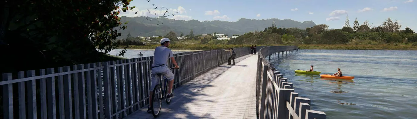
The boardwalk across the Waiau Estuary is elevated to allow small boats such as kayaks & dinghies to pass under the structure itself - including high tide. Unfortunately, sail-craft will not be able to access the Waiau Stream upstream of the new path. Due to its location at the head of the estuary, the path should have minimal impact on recreational sailing.
How will the pathway impact the environment?
The pathway’s design carefully considers environmental factors, which are considered in the Environmental Effects Assessment and other reports associated with the resource consent application here. The height of the boardwalk helps protect the natural water flow and minimises disruption to the estuary’s ecosystem. The route avoids the wetland and associated wildlife further upstream.
We're committed to protecting the Waiau Estuary during all stages of this project. Key measures include:
When is it being built?
Resource consent was granted on 14 August 2026. However, funding has not yet been secured for the detailed design and construction of the path, so there is currently no confirmed timeframe for when construction will begin. Funding will need to be secured before the project can progress to construction, with the community expected to play an active role in fundraising efforts.
Why is community support important for this project?
Community support is crucial to help raise funds, now that resource consent has been granted. If you would like to help with that, please let us know!
What is the design approach for the shared path?
The concept design was developed to be both sympathetic to the landscape and natural environment while showcasing the beauty of the Waiau Estuary. This balance ensures that the path enhances accessibility without compromising the area’s natural values. As required by the resource consent conditions, the detailed design is expected to align with the concept design as closely as possible.
What are the goals of this project?